 |
 |
 |
 |
Lake Mead Rancheros, Mohave County, AZ
Mohave Arizona Land For Sale
|
Featured Item:
|
Mohave County, AZ |
View Larger Map |
1.25 acres in a
pristine, rural, Arizona.
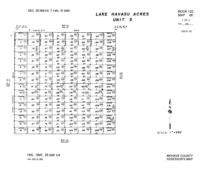
T14N R16W SEC 35 LAKE HAVASU ACRES UNIT FIVE LOT 46
|
Down Payment: $121
Monthly Payments: $50
Sales Price: $5,000
Interest Rate: 9%
10% DISCOUNT ON REMAINING BALANCE IF PAID EARLY
|
|


|
|


 |
|
Area Attractions
Hoover Dam and Lake Mead Recreational Area:
The entire Lake Mead Recreation Area stretches 60 miles and includes
Mohave Lake and Davis Dam. The Colorado River pours into Lake Mead, the
largest man-made lake in the United States. The imposing 726 foot high
Hoover Dam creates it. The area offers numerous water recreations
including, boating, fishing, water skiing, river rafting, and swimming.
Lake Havasu:
The area's focal point is the London Bridge,
which was transported from London and reconstructed in Lake Havasu. Area
locals call the bridge the world's largest antique. More than 1 million
visitors flock to the area every year to view the structure that once
spanned London's Thames River. Lake Havasu State Park covers nearly
11,000 acres and 23 miles of shoreline. It provides marinas, camping
facilities, a public swimming beach, fishing, and water sports.
Laughlin, Nevada / Bullhead City, Arizona:
Two bridges span the
Colorado River and connect Laughlin and Bull Head City, Arizona. The
Laughlin/Bullhead City airport accommodates major airlines as well as
commuter companies and many private planes. Five hundred thousand
visitors come to the area each month to enjoy gaming and the cool
Colorado River. Fine dining, nightclubs, health resorts, and shopping
opportunities are found in the area along with 12 major casinos with a
combined 11,500 +/- hotel rooms.
Grand Canyon West:
Panoramic views of the Grand Canyon may be viewed from the Hualapai
Indian Reservation. A bus tour, narrated by one of the Hualapai Indian
guides, gives fascinating information on the history and legends of the
Grand Canyon.
Grand Canyon Caverns:
210 feet underground
are the most selenite crystals of any known cave in North America. The
caverns offer an underground tour of the earth, as it existed 3 million
years ago.
Oatman:
Wild burros roam the streets in this
old gold mining town. The scenery has attracted Hollywood to film many
westerns in this town including "How the West Was Won". Also available
is a tour of the hotel where Clark Gable and Carol Lombard honeymooned.
Chloride:
Located between Kingman and Las Vegas, this old
mining town has been resurrected as a center for many talented writers,
musicians, fine artists, and craftsmen.
Historic Route 66:
Kingman lies on the longest remaining continuous stretch (158 miles
long) of Historic Route 66. Through the years Route 66 has had many
names: The Main Street of America, the Mother Road, the Wire Road, and
the Will Rogers Highway. This is perhaps the best-known highway in the
United States. Cruising down Route 66 allows the traveler to experience
many historic communities along the way.
Flagstaff:
It's a
place packed with energy, a town surrounded by natural wonders. Whether
you're looking for an easy, two-day getaway or the vacation of a
lifetime, Flagstaff will make any trip a northern Arizona adventure.
With more than two hundred restaurants, dozens of inns, plenty of
affordable accommodations, unique attractions, and colorful nightspots,
its small-town charm will give you big-town excitement. Culture, clean
air, festivals and forest paths are only some of Flagstaffs year-round
enjoyment. Some of the most beautiful country in the Southwest surrounds
you here, from lush woodlands to rugged deserts. The Grand Canyon, Oak
Creek Canyon, Sedona's red rocks, Native American reservations, and a
string of breathtaking national monuments are all within a short drive.
Flagstaff is the perfect hub for Arizona explorers, from here you can
see everything!
|
|
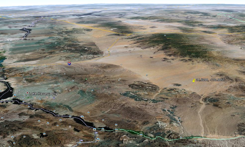
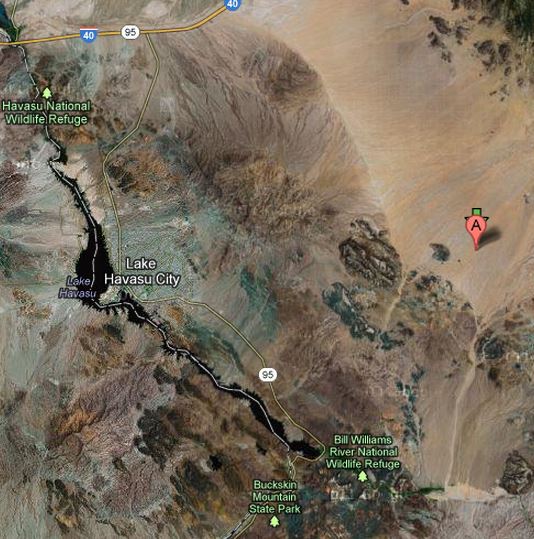
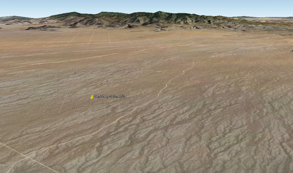
Latitude/Longitude 34.5098°N, 113.9051°W ( 34°, 30', 35.5" N; 113°,
54', 18.4" W )
The legal description is: Arizona, Gila & Salt River Meridian
T14N,R16W,sec35
UTM zone 12 (X,Y) 233292 , 3822522
The elevation is 663 m ( 2175 ft )
The gradient is: 2.1 percent
The aspect direction is: 231.7 degrees or SW
The local roughness is: 1.4 or average
The location as decimal
degrees (X,Y;Z) = -113.9051, 34.5098; 663 m
The state and county are Arizona: Mohave County 4015
The HUC is Bill
Williams 15030204; Place
point in HUC
The
Omernik ecoregion is Southern Basin and Range (more typical) 14
The 1:100,000
map (if available); Switch
to TerraServer
Zoom on that location with radius = 2
km; 5
km ; 10
km ; 20
km ; 30
km ; custom.
Nearby named places (in order by distance)
- Castaneda Wash head; -113.9064,
34.4942 at a distance
of 1738 m
- Township Tank; Arizona: Mohave Co. -113.8780,
34.5444 at a distance
of 4572 m
- Seven Hundred Well; Arizona: Mohave Co. -113.9325,
34.4736 at a distance
of 4741 m
- Desert Tank; Arizona: Mohave Co. -113.9605,
34.4994, ( 1868 ft ) at a distance of 5215 m
- Buckhorn Tank; Arizona: Mohave Co. -113.9458,
34.4581 at a distance
of 6848 m
- Eaton Tank; Arizona: Mohave Co. -113.8961,
34.4433 at a distance
of 7427 m
- Hill Tank; Arizona: Mohave Co. -113.8419,
34.5631 at a distance
of 8283 m
- Castaneda Well; Arizona: Mohave Co. -113.9047,
34.4344 at a distance
of 8368 m
- Four Hundred Tank; Arizona: Mohave Co. -113.9805,
34.4633 at a distance
of 8636 m
- Tubs; Arizona: Mohave Co. -113.8202,
34.4744, ( 2280 ft ) at a distance of 8736 m
|

  |
|
INVEST or RESELL! |
|
Arizona |
Mohave County |
|
|
|
Size |
1.25 Acres |
|
|
|
Utility Infrastructure |
No Utilities. Multiple dirt and gravel roads. Water would be by well.
Power is more than 10 miles from lot, so generator and Solar should be
considered.
Location has a warm climate. |
|
|
City: |
Kingman(not in city limits) |
County: |
Mohave |
Arizona Land for Sale
|

Taxes are $55 Per Year
|
Cities Near Lot |
Kingman |
|
|
 |
 |
 |
 |

|