Skip to product information
1 of 1

Buy With Confidence

Financed purchases include a 60-Day Principal Refund Policy, and cash purchases include a 30-Day Refund Policy—giving you extra flexibility after your purchase.

Your e-contract will arrive within 48 hours. Sign online and you’ll be ready to move forward with your property.

Colorado, Alamosa County, 5.18 Acres Sangre De Cristo Estates Replat Unit 18 Block 15, Lot 8. TERMS 50% OFF (now) $86/Month

Colorado, Alamosa County, 5.18 Acres Sangre De Cristo Estates Replat Unit 18 Block 15, Lot 8. TERMS 50% OFF (now) $86/Month

Product Code : CO_Alamosa_SDCE08U18B15Rep
Our SALES price: $8,625
Amount Due Today
Regular price $121.00 USD
Regular price Sale price $121.00 USD
  • Guaranteed Financing
  • Industry-Leading Refund Policy
  • Accessible Human Customer Support
Down Payment
$121

SSL Secure Payment

View full details

Sangre De Cristo Estates Replat

Sangre De Cristo Estates Replat, Alamosa County, Colorado

Unit 18 Block 15, Lot 8

Financing:
This lot is being offered for sale with financing. Simply make the small down payment, and the land contracts will be emailed and hard copy mailed to you immediately. You can start using or building your land while you are making payments.

Guarantee     Reviews

Down Payment: $121

Monthly Payments: $86

Sales Price: $8,625

Interest Rate: 9%

10% DISCOUNT ON REMAINING BALANCE IF PAID EARLY

Checkout bills down payment only. 10 Reasons To Buy From Us

Size: 5.18 Acres

ZONING:Residential

Utilities: No

GPS: 37.575240, -105.892890

TAXES: Approx. $115 a year

APN: 513728304029


See What You Could Do Here

Choose an idea and see it take shape on this property.

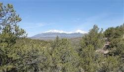
Sangre De Cristo Estates property view
What would you do with this land?

Concept visualization only. Building, zoning, utility, access and permit requirements should be independently verified.

Location and Legal Description

Sangre De Cristo Estates Replat, Alamosa County, Colorado
5.18 Acres

Sangre De Cristo Estates, CO – 5.18 Acres in Alamosa County
This Oregon Pines property in Klamath County offers a peaceful rural setting with residential zoning and off-grid potential—ideal for building, recreation, or long-term land investment.

← See All Sangre De Cristo Estates Lots


View From
8001 Stanley Rd, Alamosa, Colorado


  • Q: What makes this property unique?
    A: It offers a quiet, off-grid environment with open space and privacy in a scenic rural area.

  • Q: What can I use the property for?
    A: The land is suitable for residential building, camping, or holding as a long-term investment.

  • Q: Are utilities available?
    A: No utilities are installed, so buyers typically use solar power, wells or water storage, and septic systems.

  • Oregon Pines Land Opportunity – Klamath County, OR: Own a peaceful parcel located in the Oregon Pines subdivision in Klamath County, Oregon—an area known for its wide-open landscapes, natural surroundings, and off-grid living potential.

  • Strategic Investment Positioning: This property is positioned as a solid land investment in a rural setting, ideal for buyers seeking long-term appreciation, land banking, or a private getaway away from city congestion.

  • Flexible Land Use Options: Zoned for residential use, this parcel allows for a variety of uses including building a home, recreational camping, or holding as an investment. Oregon properties are managed at the county level, where zoning and land use rules are established locally.

  • Off-Grid Ready Environment: No utilities are currently installed, making this ideal for off-grid living. Typical setups in the area include solar power, water storage or wells, and septic systems.

  • Quiet & Scenic Location: Located in a remote and peaceful setting, this property offers privacy, open skies, and natural beauty—perfect for those seeking space, independence, and a slower pace of life.


Alamosa County is a county located in the U.S. state of Colorado. As of the 2020 census, the population was 3,499.The county seat is San Luis, the oldest continuously occupied town in Colorado.

On July 8, 1694, Spanish Conquistador Don Diego de Vargas and his army, two weeks before the Battle of Astialakwa, reached Costilla County. Diego Vargas is not the first Spaniard in Colorado. Juan de Archuleta led an expedition into Colorado in 1664 - but his expedition is the first traceable Spanish expedition into Colorado. In 1647, Governor Luis Rosas fought with the Utes in northern New Mexico. While Rosa came near Colorado, it has not been verified he actually did.

Costilla County was the first area of Colorado to have civilized settlement. The county made up the major part of the Sangre de Cristo Land Grant awarded by the government of New Mexico to the Carlos Beaubien family in 1843. Hispanic settlers from Taos, New Mexico, officially established San Luis on April 9, 1851.Costilla County was one of the original 17 counties created by the Territory of Colorado on November 1, 1861. The county was named for Costilla Creek. San Miguel was originally designated the county seat, but the county government was moved to San Luis in 1863. (In 1869, surveys placed San Miguel in the New Mexico Territory.)

The county's original boundaries extended over much of south-central Colorado. Much of the northern portion became part of Saguache County in 1866, and the western portions were folded into Hinsdale and Rio Grande counties in 1874. Costilla County arrived at its modern boundaries in 1913 when Alamosa County was created from its northwest portions.
Costilla County According to the U.S. Census Bureau, the county has a total area of 1,230 square miles (3,200 km2), of which 1,227 square miles (3,180 km2) is land and 304 square miles (790 km2) (0.3%) is water.

It is the ninth-least populous of the 64 counties in the U.S. state of Colorado. As of the 2010 census, the population was 3,524. The county seat is San Luis, the oldest town in Colorado.

Costilla County lies in south-central Colorado within the San Luis Valley. It covers nearly 1,227 square miles and ranges in elevation from 8,400 to 10,300 feet. Costilla County borders Conejos County to the west, Alamosa County to the northwest, Huerfano County to the northeast, Las Animas County to the east, and the state of New Mexico to the south. Classified as a high alpine desert, it generally receives fewer than eight inches of precipitation per year, forcing local farmers and ranchers to rely on underground aquifers and mountain reservoirs for water. The county lies to the west of the Sangre de Cristo Mountains, which boasts several peaks above 14,000 feet, including Blanca Peak, Crestone Peak, and Culebra Peak.

👉 Contact us today to secure this Colorado land opportunity!


New Mexico Land

  • Buy Online in Minutes

    Complete your purchase from anywhere with just a few clicks.

  • We're With You Every Step of the Way

    From first click to deed delivery, our friendly support team is here to guide you.

  • Fully Transparent Terms, No Hidden Fees

    What you see is what you pay—clear pricing and zero surprises.

Exploring your options? Get the facts in our Learning Center.

Off the Grid E-book

New Mexico Land
New Mexico Land
New Mexico Land
New Mexico Land
New Mexico Land