Home > Kentucky > Sold >

Kentucky, Wayne County, 2.07 Acre The Cliffs, Lot 3, Water View. TERMS $139/Month


Our Price: $13,998
Down Payment $121.00

Down Payment with Selected Options: $121.00

Quantity in Stock:SOLD

Product Code: KY_WAYNE_THECLIFFS_03


Down Payment Option*:


Qty:  
Description
 

The Cliffs

2.07 Acres The Cliffs, Wayne County, Kentucky. TERMS $139/Month

LOT 3

Financing:
This lot is being offered for sale with financing. Simply make the small down payment, and the land contracts will be emailed and hard copy mailed to you immediately. You can start using or building your land while you are making payments.

Down Payment: $121

Monthly Payments: $139

Sales Price: $13,998

Interest Rate: 9%

10% DISCOUNT ON REMAINING BALANCE IF PAID EARLY


Checkout:
The checkout above bills the down payment only.


Location and Legal Description

Lot 3, The Cliffs, Wayne County, Kentucky
2.07 Acres

The Cliffs is a small rural piece of land located on the Cumberland River. Due to it's steep elevation, this land is for recreational use only. Cumberland River is excellent for trout and striped bass fishing or other water activities. Our no-hassle, guaranteed financing make this the perfect opportunity for you to own a small portion of the beautiful state of Kentucky.


View From 5052 KY-790 Bronston, Kentucky
Entrance to subdivision

SIZE: 2.07

TAXES: Less than $5 per year, per acre and are current.

UTILITIES: Water View

ZONING:Residential

Elevation: average is approximately 840 feet.

Dirt road legal easement with unmaintained dirt roads/trails

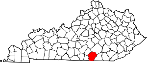
Wayne County is a county located in the U.S. state of Kentucky. As of the 2010 census, the population was 20,813. Its county seat is Monticello.

According to the U.S. Census Bureau, the county has a total area of 484 square miles (1,250 km2), of which 458 square miles (1,190 km2) is land and 26 square miles (67 km2) (5.4%) is water.

The county's elevation ranges from 723 feet (220 m) to 1,788 feet (545 m), at the Monticello/Wayne County Airport the elevation is 963 feet (294 m). Wayne County is located in the Pennyrile Plateau (image) and Eastern Coal Field (image) regions of Kentucky.